Tourism
Sirmaur is the southern most district in the south-eastern region of Himachal Pradesh, India. It is largely mountainous and rural, with 90% of its population living in villages. Some of its popular towns include Nahan (the capital), Paonta Sahib and Suketi, the latter famous for the Shivalik Fossil Park where fossils over 85 million years old have been found.
HISTORY
Sirmaur was an independent kingdom in India, founded in about 1090 by Raja Rasaloo of Jaisalmer, one of whose ancestors was named Sirmaur. It became an 11 Gun Salute princely state in British India,The premier ruler of the Punjab Hills, located in the region that is now the Sirmaur district of Himachal Pradesh. The state was also known as Nahan, after its main city, Nahan. Sirmaur was ruled by the chiefs of Rajput lineage, who used the title “Maharaja”.
CULTURE
A majority of the population is Hindu and hence most people worship Hindu deities (devtas) and observe various related customs and rituals. The local language is Sirmauri.
Bishu is a popular fair that is held at several places, and features the Thoda dance. Nati, Gee, Rasa and Budhechu are the popular styles of folk dance in Sirmaur. These are enjoyed at occasions such as weddings and the Diwali festival.
PLACE OF INTREST
There are many small towns and scenic places in Sirmaur District.
NAHAN
Nahan is a town in Himachal Pradesh in India and is the headquarters of the Sirmaur District. It is also the location of the Indian Army Special Forces Training School. It was the capital of the former Sirmur princely state.
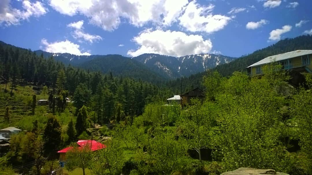
HABBEN VALLEY
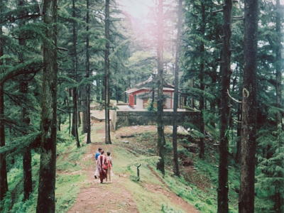
Habben Valley’s best known temples are Shirgul Devta, Palu Devta and Tokro Tibba Kali Maa. At Habben there are two well known temples, Tokro Tibba Kali Maa and Palu Devta. Haabbi 1500, a well known Rajoot caste, belongs to these two Devtas. Lord Shirgul Temple is one of the most famous temples in North India. Lord Shirgul is worshipped in Sirmaur, Solan, Shimla, Uttaranchal, and Delhi. Thick Deodar forests are visited by tourists from many parts of India. A trek leads to Churdhar, the Holy place of Lord Shiva.
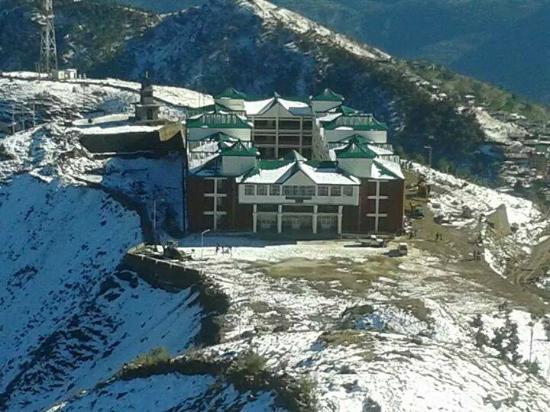
CHURDHAR
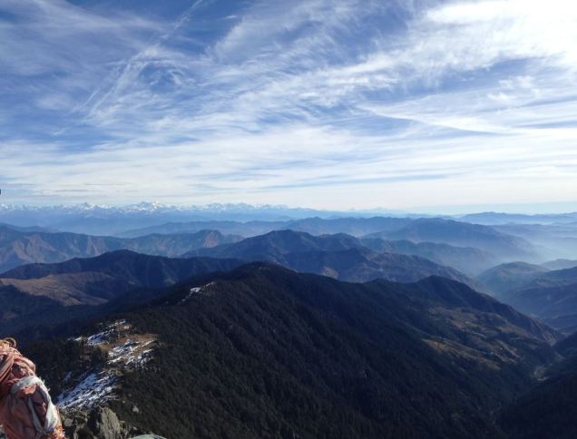
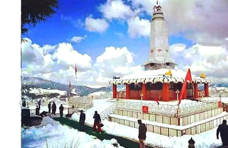
The Chur Peak in district Sirmaur rises to an elevation of 3647 m above the sea level. The mountain is an important religious place for all Sirmauries. It is one of the Shivalik ranges at a height of 11965 feet, and is the highest peak in southern Himachal Pradesh. Churdhar, also known as Churchandni (Bangle of Snow), is known for its spectacular landscapes. The view from the summit offers a panorama of lowland tracts towards the south and snow-capped ranges, including the peaks of Badrinath and Kedarnath in the Garhwal region, towards the north. It is believed that this is the very place where Hanuman discovered the life-restoring Sanjivini booti, which revived Lakshmana, Lord Rama’s younger brother. Ruins of an ancient town have been discovered at the nearby dundi Devi.
Herbs and alpine flora cover these Himalayan slopes, and fauna include the monal, Himachal’s state bird, along with koklass and kaleej pheasants.
Trekkers tread over small glaciers on their way to Churdhar summit, which has moderate to heavy snowfall (average of 33 feet snow). Often the Shirgul temple gets buried under it. On clear sunny days, the Badrinath and Kedarnath shrines, Gangetic plains, the Sutlej river and hills of Shimla and Chakrata can be seen. Atop the Churdhar summit there are lingams of Shiva and Kali, where goat and sheep were formerly sacrificed. Devotees hoist flags and make offerings here.
The peak can be approached from Dadahu, headquarter of Renuka tehsil, via Sangrah, Bhawai, Gandhuri and Naura, at a distance of about 48 kilometres (30 mi) by bridle path. Another approach to the peak is by the Solan Rajgarh Menus road.
Renuka Ji
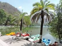
Renuka is another place of religious and tourist interest in Sirmaur. It is nearly 40 kilometres (25 mi) from Nahan via a motorable metalled road. Boating is available for visitors at Renuka Lake, an oval-shaped lake with a circumference of 2.4 kilometres (1.5 mi). The lake is visited by thousand of pilgrims every year on Kartiki Ekadashi. There is a 1.6 kilometres (0.99 mi) patch between the Giri and humming camp where visitors often stay for a couple of days. Nightlong festivities including Kirtans are held by various groups.
The place reaches full capacity during the days of the fair and offers a variety of activities. At the entrance to the fairground there is a notice board put up by the Wild Life Wing of the Forest Department warning, “Hold Your Gun–Game Sanctuary Starts”.
To this fair, the brass idol of Parasu Rama is brought from the village Jamu, his permanent abode, in a silver palki accompanied by musical instruments. The deity remains in the temple for three days i.e. sudi, dashmi to dwadashi (from 10th to 12th of the bright half). The hill people pray to pujari with questions during the night when he goes into a trance and turns into an oracle, answering questions and sometimes asking of the questioner some offering or sacrifice to the deity of some other act as a condition precedent to the fulfillment of the favourable prophecy, such as deliverance from a problem or recovery of health from some disease. On Dwadashi, generally, the people offer alms after the holy dip in the Renuka lake.
HARIPUR DHAR
This place is at an elevation of 2687 m. Maa Bhangayani Temple, Haripurdhar, is a well known temple in Sirmaur. Haripur is the name applied to a mountain called Haripur Dhar. A fort on a peak of this hillwas built on this range of mountain by the rulers of erstwhile Sirmur State. It was primarily meant to guard the state frontiers with the neighbouring Jubbal State as there were constant boundary disputes between the two states and there was an unusual encroachment into each other’s territory. It has fallen into disuse and the part which is still habitable is used by the Forest Department as forester’s headquarters. The fort reminds the visitor of the historical period when to hold or capture such forts used to be the chief aim of the contending hill states. At a distance of about 106 kilometres (66 mi) from Nahan, Haripurdhar can be approached by a regular bus service covering 40 kilometres (25 mi) up to Dadahu, wherefrom Andheri can be reached by jeep for about 44 kilometres (27 mi). The remaining portion is about 22 kilometres (14 mi). Another way to approach is from Solan via Rajgarh. Kharotiyon, a place from where the site of the fort remains about 2 kilometres (1.2 mi) on the hill top.
BHURESHWAR MANADEV
Bhureshwar Mahadev is another religious and tourist destination in sirmour district. It is situated on a peak nearer to Sarahan on the Nahan – Solan state highway. There is a legend about this place that from here Mata Parvati and Lord Shiva saw the Kurukshetra War, as described in the Mahabharata. From here Chandigarh can also be seen.
PAONTA SAHIB (398m)
This town surrounded by Sal forests and on the banks of river Yamuna was founded by the tenth Sikh Guru, Gobind Singhji, who stayed here for more than four years. Gurudwara Tirgarh Sahib (22km), Gurudwara Bhangani Sahib(23km) and Gurudwara Shergarh Sahib (12km) are other Sikh shrines to be visited when in Paonta Sahib.
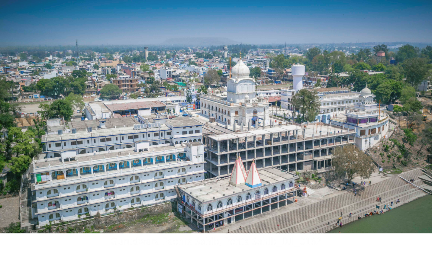
GURUDWARA PAONTA SAHIB
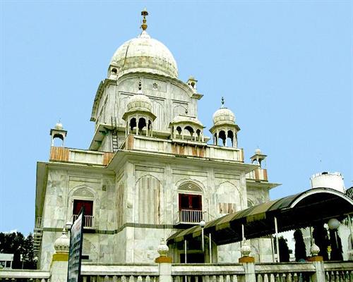
Gurudwara Paonta Sahib, is a noted Gurudwara in Paonta Sahib, District of Sirmour, Himachal Pradesh.
This Gurdwara was built in memory of Guru Gobind Singh ji, the tenth guru of sikhs .The Dasam Granth was written here by Guru Gobind Singh Ji. Hence, the Gurdwara enjoys a high historic and religious importance among the followers of the Sikh religion world over.The Gurudwara have a palanquin “Palki” made of pure gold, donated by devotees.
SIMBALBARA NATIONAL PARK
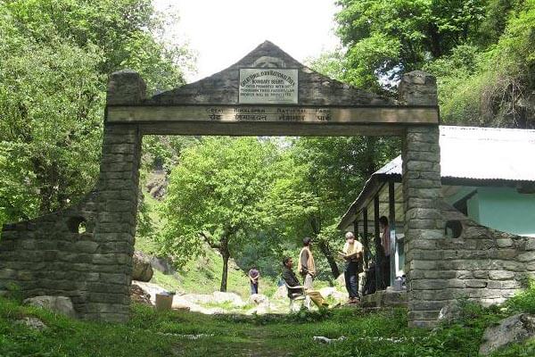
Simbalbara National Park is a national park in India, located in the Paonta Valley of Sirmour District, Himachal Pradesh, along its border with Haryana. The vegetation consists of dense Sal forests with grassy glades. The protected area was created in 1958 as the Simbalbara Wildlife Sanctuary with 19.03 km²
SHILLAI
Shillai Subdivision of Sirmaur Distt, which includes the area from Sataun to Haripur Dhar is a tourist destination for people from India and abroad, especially in summer season. NH-707 (old NH-72) is the national highway as from Paonta Sahib to Hatkoti.
BALASUNDARI AT TRILOKPUR (35 km from Nahan)
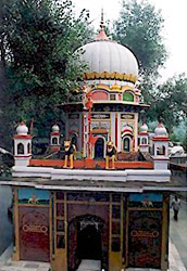
Balasundari Mata at Trilokpur is the biggest draw of pilgrims from the neighbouring State of Haryana. The object of veneration here is a pindi of Devi that emerged from the earth in 1753. An image of Devi has also been installed and the masons were invited from Jaipur to build a temple. Legend has it that the Devi’s pindiappeared in the bag of slot brought by a local trader. The temple built by Raja Deep Parkash of Sirmour in 1573. close by is a recently built Shiva Temple.
SAKETI FOSSIL PARK (15 km from Nahan)
The site of largest fossil find in Shivaliks now converted into a Park where there are life size models of the extinct animals made of fiberglass. The park has a museum and life-size models of the animals that once roamed these tracts. 60 km from Sirmour.
JAITAK FORT
The Jaitak fort and hills is a historical place in the annals of Sirmour. It was here that the most important battle was fought between the British forces and the Gurkhas. Jaitak is the name applied to a peak, or rather two peaks. About 19 km to thenorth of Nahan, Jamta falls on the Nahan-Dadahu motorable road. An ascent of about 3 km has to be negotiated form Jamta to gain Jaitak.
RAJGARH (2169m)
It is 30-40 km from Solan. Blessed with natural beauty, the place is known for apple and peach orchards. A rest house and few eating places make it a convenient place to stay. Situated at about 5000 ft. from sea level, Rajgarh is sub-divisional head quarter of Sirmour Distt. It is situated nearby Giri river which is a tributary of river Yamuna.